- /
- Katun Road Borderline Heights
- /
- General Information
- /
- Signalization on the Trail
Signalization on the Trail
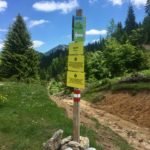
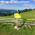
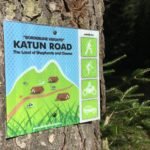
Signalization has been set along the complete trail and it looks like this:
Billboard – they are set at the connections with the main road and they look like this.
Road sign – these signs are made in such a manner that you know for sure how far away the next katun is from your location, as well as the katuns that follow. The sign has a vertical writing KATUN ROAD to make it easy for you to see the trail you’re on and not to get confused by some other road signs you may come upon. If the sign has a vertical writing EXIT ROAD, then it shows you the fastest way to leave the trail and access the nearest main road. Anyway, you will find these road signs at every important crossroads of the trail.
Pictogram arrow – we have set arrows on places where side roads branch from the main one, for you to be certain where to go. These arrows show left or right. If you are still confused, or if the arrow is missing, just head along the main road and you will soon come upon some of the control points.
Pictogram control point – these pictograms are set along the entire trail, their purpose being to show the visitors that they are on the trail. They are very frequently set, and if you hike along the trail and you see no pictogram, it means that you have turned off somewhere. This pictogram also says who this trail is designed for – hikers, cyclists, bikers and terrain vehicle drivers. One more thing, riding a bike or driving a terrain vehicle is not allowed anywhere else except along the macadam roads.
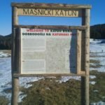
Info boards – info boards are set in all the larger katuns, and besides the name of the katun you’re in, they also provide a detailed and precise map with your current location marked.
Signs for springs – You will find loads of drinking water on the katun road, since these mountains are abundant in springs. These places are marked with this pictogram.
Viewpoints – since you are at a great height, the view is always very beautiful. But, there are places that we warmly recommend because the view from them is spectacular.
Info text – these boards give you additional information that can be useful. If these boards are only in Montenegrin language, they are designed for local population then; all the significant information for tourist are translated into English language.
For even more precise orientation, you can download the track log of the Katun Road here.


